Zunibal: Innovation at the service of tuna fishing
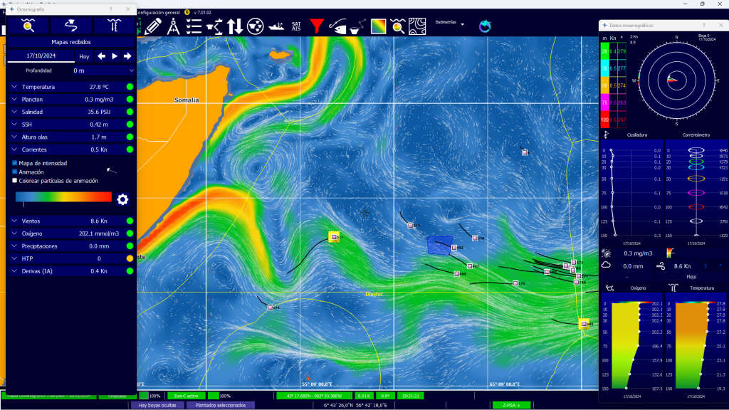
Zunibal, with almost three decades of experience in innovative solutions for sustainable tuna fishing, presents the new version of its software to assist the tuna fishing fleet. Specially designed as a buoy operation and management system for tuna fleet skippers, it has been an essential tool for almost 30 years. It provides accurate information and advanced features that facilitate and improve decision-making. Now, this update incorporates an evolution in the interface, offering much more visual and intuitive oceanographic maps and functionalities based on artificial intelligence and machine learning, maintaining Zunibal’s commitment to equipping the tuna fleet with the latest technology.
To delve into these new features, Industrias Pesqueras interviewed Zunibal’s R&D Director, Aitor Aizpurua, who shared details about the technical advances and their impact on the industry.
Aitor Aizpurua explained that the software solution update responds to the growing complexity and demands of the fishing sector. “Today’s fishing demands tools that offer accurate information in real time,” he said. “Our goal is to create solutions that facilitate the use of that information, allowing professionals to make decisions based on reliable data and achieve more efficient operations.”
Understanding the situation and interpreting the context is crucial to making informed decisions that increase the efficiency of fishing operations, Aitor stressed. “For this reason, we add oceanographic data to the position and biomass provided by our buoys. These maps are updated worldwide every day, and some of them several times a day. Variables such as salinity, altimetry, and plankton are key when choosing one or another fishing area. In our interface, users can customize these maps with the information provided by the system. In addition to the maps, it is also important to know other oceanographic data such as temperature, shear, and currents at depth.”
He also stressed that the key to providing added value to oceanographic maps is the use of Machine Learning and Artificial Intelligence to recommend the best fishing areas and optimal route planning. “We have developed tools such as Hot Tuna Point, maps of optimal fishing areas based on oceanographic models and biomass estimates made by buoys, capable of reducing fuel consumption by indicating the area with the highest probability of success, and even facilitating free-school fishing, by recommending the area with the most favorable habitat to find tuna.“

Among the most outstanding new features of this update is the new functionality of Drift maps, which represent the predicted trajectory of the buoys and are produced using Machine Learning techniques. To create them, the model is trained considering different oceanographic variables, such as wind and currents, both current and historical. “Drift maps reflect the actual speed and heading of the buoy, taking into account the submerged part of the object,” explained Aitor. “This tool offers more accurate estimates and helps optimize fishing operations by anticipating the behavior of Fish Aggregating Devices (FADs).”
In addition, oceanographic maps now have a higher resolution, which translates into greater accuracy in identifying optimal fishing areas. “With more detailed and accurate information, professionals can make more informed decisions, optimizing routes and increasing the efficiency of fishing operations,” he said. “It is possible to view the maps received individually or as an animation, which facilitates the analysis of oceanographic conditions and improves planning.”
Aitor concluded by emphasizing Zunibal’s commitment to innovation and sustainability in the fishing sector. “We will continue to develop solutions that make it easier for professionals to carry out their daily work and contribute to more efficient and responsible fishing.”
